Garmin GPSMAP 8410
Refurbished
GPSMAP 8410 Chartplotter with 10" touchscreen and Full HD IPS (In-plane Switching) screen, GPS-only/Chartplotter version without depth sounder
Premium 10" Full HD widescreen multitouch display
Possibility of recessed or flush installation, for a wonderful super-technological crystal console
Built-in Wi-Fi® and ANT™ connectivity, 4 Ethernet ports, NMEA 2000® port, HDMI and USB port for total integration
Advanced Garmin SailAssist™ features for sailing
With SmartMode™ you can simultaneously change all the screens of the GPSMAP displays interfaced with each other for mooring, cruising, fishing, anchoring and much more
A wonderfully powerful instrument, 360° integrated, enclosed in an ultra-clear 10" full HD touch screen: a display like this has never been seen among on-board instruments. GPSMAP® 8410 is equipped with a high-performance processor to process the cartography with unprecedented speed and allows you to customize screens, data and indicators. Everything is designed to allow the user to quickly access, with a single gesture, all the information necessary in the most stressful situations, such as mooring.
GPSMAP 8410 chartplotter/GPS with 10" touchscreen and Full HD IPS (In-plane Switching) screen
Premium 10" Full HD widescreen multitouch display
Possibility of recessed or flush installation, for a wonderful super-technological crystal console
Built-in Wi-Fi® and ANT™ connectivity, 4 Ethernet ports, NMEA 2000® port, HDMI and USB port for total integration
Advanced Garmin SailAssist™ features for sailing
With SmartMode™ you can simultaneously change all the screens of the GPSMAP displays interfaced with each other for mooring, cruising, fishing, anchoring and much more
A wonderfully powerful instrument, 360° integrated, enclosed in an ultra-clear 10" full HD touch screen: a display like this has never been seen among on-board instruments. GPSMAP® 8410 is equipped with a high-performance processor to process the cartography with unprecedented speed and allows you to customize screens, data and indicators. Everything is designed to allow the user to quickly access, with a single gesture, all the information necessary in the most stressful situations, such as mooring.
Create your own integrated system
By connecting the GPSMAP® 8410 to the Garmin Marine Network it is possible to view on the display the data processed by on-board instruments such as radar, autopilots, depth sounder modules, multimedia devices (FUSION-Link), thermal cameras, GRIDs and much more. The GPSMAP® 8410 also allows you to share information with other compatible GPSMAP units, such as maps and user data, including waypoints, routes and tracks. This means that user data entered can be automatically synchronized with other chartplotters on the network.
Unlimited connectivity
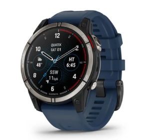
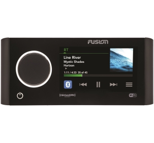
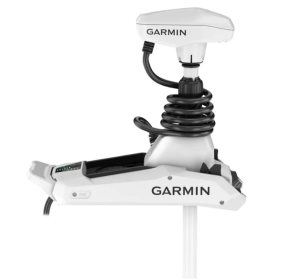
The new GPSMAP® 8410 chartplotter integrates seamlessly with a variety of onboard instruments thanks to integrated Wi-Fi® and ANT+ connectivity, 4 Ethernet ports, NMEA 2000 network, HDMI port, USB port and many more. It is also compatible with FLIR cameras. Built-in Wi-Fi technology lets you use the free ActiveCaptain® app to access OneChart™, Smart Notifications1, Garmin Quickdraw™ community data, and more. You can also control streaming video playback from the GC™ 100 Wireless Camera and VIRB® Action Cameras. Plus, built-in ANT wireless technology allows you to directly connect your quatix® watch, gWind™ Wireless 2 transducer, and wireless remote controls.
Digital Switching
Completely new interface for managing the MasterBus and Czone on-board networks. You will be able to start the engines, activate the pumps, turn on the underwater lights and monitor the warning lights directly from the chartplotter screen, all thanks to intuitive and easy-to-use graphics.
The best of Garmin and the best of Navionics®
The new GPSMAP® 8410 display is compatible with the latest
Garmin BlueChart® g3 and BlueChart® g3 Vision cartography, which integrates BlueChart data with Navionics data to deliver the best cartography ever. This new cartography also includes Auto Guidance technology, which allows you to avoid dangers and obstacles, developing safe routes to destinations set based on the characteristics of the boats 2.
Take control while sitting comfortably 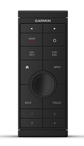
You no longer have to stand at the helm for hours. The intuitive optional GRID™ 20 remote control provides remote access and maximum control over the entire on-board Garmin system. Includes a 360-degree rotating joystick, rotary dial and push-to-select button for simplified navigation and precise control of menus and chartplotter settings, even in rough seas.
 Regatta functions
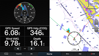
The new GPSMAP® 8410 chartplotter has a useful function dedicated to those who sail or compete in regattas. Thanks to SailAssist™ it is possible to view on the screen the right moment to tack or jibe, simultaneously view the apparent and real wind angle, keep the tides and currents under control, view the direction and course line at the same time, activate the Pre-race guidance function to cross the starting line at the right time and with maximum speed and keep the wind under control thanks to the intuitive graphs.
Make your boat smart
Use the new ActiveCaptain™ application to connect your Garmin Marine chartplotter to the mobile network and make your boat smart. ActiveCaptain™ is free and will allow you to make the most of your on-board equipment.